Sampson-Richland Rd. Trail Watagua/Caldwell County

Yerby

Well-Known Member
Joined
Mar 24, 2005
Location
Newton, NC
Sampson-Richland Rd. Trail Watauga/Caldwell County

Group,

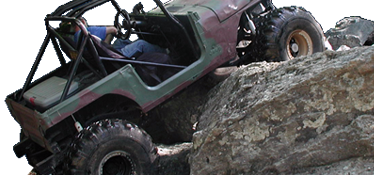
I took my Rubicon, yeah i know it is over kill, on the Sampson-Richland road trail for the first time. Little rocks for the first few miles, a few mud holes and then several creek crossings near the bottom. I never used 4wd on the entire ride. There appears to be several trails that branch off and I will explore those in the not-to-distant future.

I talked to a Deputy sheriff in Caldwell county and he said that the landowners were highly upset at the "off-roaders" and the amount of distruction that they have done. It is apparent that they mean the dirt bikes and four-wheelers and not 4WD enthusiasts. I picked up half a bag of trash by myself just to improve our image.

Fun little Trail that you could incorporate into a trip to Boone or Blowing Rock for a well-rounded day.
 
Yerby, we both enjoy a trip to Richlands, but please don't explore the off shoot trails without a landowner's permission. None of the other trails aside from the main road are legal. I found this out the 1st time i went up there and saw 2 kids in an S-10 held by a landowner until the police arrived. The cops were none too happy after having to call in a 4x4 to get to the location (this was before they "paved" the trail) and they were not very lenient on the 2 guys when they got there (from what I remember, the charges were tresspassing, public intoxication, underage drinking and DUI). The road is subject to all state laws (seatbelts, drinking, etc..).

I see you are in Newton, PM me and we can go wheeling sometime in something that WILL require you to use those little switches under the radio. I am in Newton off of Sigmon dairy road.
 
321N towards Blowing Rock. Right turn onto Richland Road about halfway up the mountain. Continue until the stream crossing and continue to the top of the mountain.
You will have to turn around and come back down the way you came. The back side is all private roads, from what I was told.
 
What uglyjeepoffroad said: stay off private land or you make things worse on all 4-wheelers.

Be careful out anywhere on your own... anyone making meth is probably armed and will not hesitate to shoot you if you cross their path.
 
uglyjeepoffroad said:
321N towards Blowing Rock. Right turn onto Richland Road about halfway up the mountain. Continue until the stream crossing and continue to the top of the mountain.
You will have to turn around and come back down the way you came. The back side is all private roads, from what I was told.
where do you have to turn around been there 100's of times always turn around at the big open area always told the road connects and comes out near leatherwood horse ridding park
is that part private??????
 
Hey Stone i agree with you about the turn around and from what my brother in law says, the Whole road is public owned all the way back to the main dirt road. One of his friends lives up there and thats the way they go in.
 
stone4x4 said:
where do you have to turn around been there 100's of times always turn around at the big open area always told the road connects and comes out near leatherwood horse riding park
is that part private??????

I have always turned around at the top before you come up to the houses at the top. There are a few extra rocks on the trail above the "playground". I have been down the backside one time, but it involved a landowner opening a gate for us. I really don't know the way down, so there may be a way down that is legal.
There are always some burned cars and trash up ther. I have packed out many bags of trash and I try to keep it clean, but it is definitely an uphill battle. I try to always go with some one up there, you never know what is going on in the woods, or who you may come up on. :eek:
 
To get there from 321, take 321 to Richland Rd and follow Richland road to the end. At the end, there are a couple of driveways and a trail that goes across the creek. Go across the creek and follow the trail up.

The other way is to take the BRP (Blue Ridge Parkway) north from US321 to Aho Gap (or Aho Gap Rd. from 321 in between Blowing Rock and Boone) to Sampson Rd.

Follow Sampson for about 2 or 3 miles until you come to an Telephone substation on the left, and then take the next right.

There will be a Road sign, Penley Rd or something. Just follow that and it will become the trail. this will lead to the large dirt turnaround area that they discussed above.

About the Meth Warning. Watauga county has more meth lab busts than any other county in North Carolina. It is an epidemic there. Caldwell county is just about as bad. Along the upper part of the trail from Sampson Road to the large dirt area, there are many cottages and abandoned buildings that would be perfect for meth.

I work in state law enforcement and realized that the dangers were present, ya'll be careful out there.

I still feel that there is a trail that links Sampson road to Buffalo cove in Wilkes county that I will try and figure out.

Have fun and be safe.

Yerby
 
Thanks for the directions, Yerby. Let us know if you ever figure out the connecting trail...
 
Rr

I was there last fall. Drove all the way thru. No signs anywhere that said to keep out or private land ect. But as was told, stay on main trail. The trail is pretty junked up, esp near the "play ground" burned out cars, litter and so on. When my kids were small I used to take them there often for pic-nics. KInda a cool lil trail, going all the way thru you start in Caldwell County, into Wataga County, over into the corner of Wilks County and back into Caldwell.

Glad to hear you guys are picking up trash.

Chip
 
Yerby said:
It is apparent that they mean the dirt bikes and four-wheelers and not 4WD enthusiasts.
Be sure of this before you go back. Remember...Non wheelers tend to lump ALL off road vehicles together. So they may not like the 4x4 rigs simply by association.

I picked up half a bag of trash by myself just to improve our image.
Livin' Tread Lightly...good on you.
 
The trail from Buffalo Cove exists and was gated on the Buffalo Cove end a few years ago (Wildlife Management Area), but it's easy find once you know which trail it is off the Richlands Rd. What might be true now is that it's closed altogether, and the safest way to find out is to go in from the Richlands Road end and see if you run into gates or trespassing signs. It'll come out on Cottrell Place or Rd which runs into Stone Mtn Rd that'll take you out to Buffalo Cove Road. The trail runs east off Richlands between the old bridge and the hillclimbs/turn around area. As you come in from the 321 end, it runs at an angle back to the right along the top of the ridge just past the sharp s-bends. The s-bends will be after the rocky area above old the bridge.

If you decide to explore, keep making lefts at all T intersections where a left or right decision is necessary, IIRC. There are lots of trails that lead off to either side along that ridge trail. Near the Buffalo Cove end the trail starts down the ridge and gets rougher. As you come down the last part of the ridge to the gate, if the gate is open, proceed down until it comes into another trail at a sharp angle. Turn hard left and proceed past the back side of a house and you'll come out on Cottrell Pl or Rd. If you were to take the right, it would lead you back to into the trails that run off the ridge trail and eventually end up in those locked gates you passed on the way in from 321.
 
Pathmaker said:
this sounds like a pretty easy trail, does anyone think my friend with an all wheel drive subaru outback could make it up?

I made it up a several years ago, when my 4wd actually worked. Give me a holler sometime and we'll take a go at it. From look of it back then theres not much need for any 4wd.
 
Its still there and yeah it is public road. Its an old fire road from what Ive been told. If you look it up un a map I think its actually Penley Road. Alot of the land is Private on either side of the trail and most of the trash is from what was said "the non wheeler crowd". You can go all the way through and it comes out close to the parkway or 321(depending on how you go in). Good lil place for the lesser experienced, but playing in the creek can be fun......

ai248.photobucket.com_albums_gg196_mcbeerob_Richlands_20Trip_IMGP0659.jpg


ai248.photobucket.com_albums_gg196_mcbeerob_Richlands_20Trip_IMGP0661.jpg
 
Back
Top