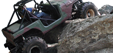
Well, what would a group on 42s, lockers, doublers and a disregard for damage get into?
You should be able to attempt everything at Callalantee, course you might not make it

On the Welder trail, the waterfall is a nice 7 foot ledge with water coming over it. A hole is eaten out on the right side and presents a flop possibility, hug the tree at the top left. The Step is also eroding nicely and is much harder than in the past, especially when wet. Easy Out, is still maturing as a new section. The lower part has some good sized rocks and leads to a flat slickrock area then up to a step out. Several lines are available here from mild to wild, make it easy on yourself. The Loop looks good from the bottom entrance but is really not
much of a trail but it is steep coming back down! The Rut is easy after the first step up, if there's no traffic and you want to loop welder come back down this way. Take all the left lines after The Loop to the top for the best challenge.
Off the Orange trail, Armor All can be tough in a couple of places, enters left into the creek after you come off the Green trail. This trail used to be much longer before it was "closed" due to silt run off and there are some really good areas that need to be re-cleared. The exit can be quite a challenge when wet and brings you out at the entrance to Little Tellico and Big Tellico/Pull Cable.
Little Tellico also used to be much longer but logging operations closed a good portion of the trail and altered it's character. It's still a nice option for lesser built rigs and is a nice way to get on or off of Big Tellico/Pull Cable in case you can't make the entrance or need to get off of it because of breakage.
Big Tellico/Pull Cable is probably the hardest section at Callalantee. A short, 200 yard section, moderate up hill incline, with boulders large enough to stay in place for the most part. The entrance can present a challenge with the left line being the easiest. A good spotter can make this trail section look easier than it really is, a bad spotter or no spotter can make it really difficult. There a a couple of exits/entrances onto Little Tellico, one half way up and one close to the top. A little work at the top with chain saws to clear logging debris would open several more exit lines, some of which could be quite tough.
The Yellow Rock Garden can be a little difficult to find but also has some tough challenges and offers the possibility of more trail with a little work. The left side is toughest with lots of loose rock at the base of a large step, 4' or so. Additional clearing would open up some other, possibly tougher, lines on this side. The right side is doable by most rigs willing to work it a little and has undergone a change since it was opened from challenging to easier to harder now that it has eroded some. Both sides meet at the top and lead to a very steep descent back to the bottom.
The A.O.R.C. Rocks area is the fartherest from camp. It is not finished, i.e. there is no exit at the top and I'm not sure anyone has ever made it to the top. It is a steep, loose rock area that would require some wheel speed to ascend with the very real chance of cutting a tire as the rocks are quite sharp. This section needs work. It could connect to an old logging road at the top which would exit back to the trail system but no one has taken the initiative to finish it and I think this says a lot about the risk/reward factor of this section.
The rest of the trail system is similar to what you find at any logging site. Lots of Forest Service type gravel roads, many trails that are very steep which can be tough when wet, lots of stream crossings, and lots of possibilities for new sections with a little clearing.
I've been riding Callalantee for about 10 years, since it was a horse camp and CTB rode the trails for Mr. Brown to keep them clear for the horse riders. It has gotten better and better each year and still has potential for growth. Not one of the best venues in the south but definately worth a trip a couple of times a year. The bath house can be filthy at times, is marginal at it's best. The camp sites are also marginal with lots of gravel, dust and the ever present ATV's flying around at all hours. Avoid summer if possible. The best rides are mid winter when the crowds are down and the leaves are off the trees allowing views from Skyline Drive. $11 to ride daily, $10 to camp, honor system box at the entrance cabin if no one is there, which is most of the time.
 Callalantee has some good, read hard, areas to ride. Not like Tellico or Harlan but worth a trip.
 Callalantee has some good, read hard, areas to ride. Not like Tellico or Harlan but worth a trip.
