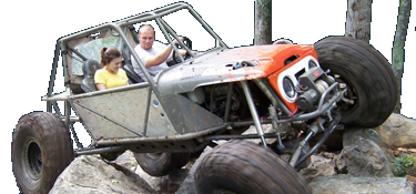
Lake Houser Adventures.

jackedHB

Member
Joined
Apr 3, 2005
Location
Boiling Springs
I talked with Wayne (owner) the other day at church, he said he had some places he was trying to make plans for there and if anyone had some ideas or whatnot to give him a call. He was looking at one hill to pile rocks on so that maybe that is something we can help with. He told me that it gets more crowded when Brown Mt. and Uwharrie close for the winter, and that he would like to have more trails set up for vehicles other than fourwheelers.

If anybody is interested in getting together sometime and going by to talk with him let me know I am off everyother saturday and would be more than happy to go by and get something going.
 
That would be the place, he is really showing interest into opening this up more for us. He just needs some help and people who can lead him in the right direction.
 
I have talked to him before letting him know that I am more than willing to help out with maintenance and whatever else he needs down there. Robert (Dawgtoy) is real active down there too and has envisioned a few new trails.
 
yeah Ive rode fourwheelers there a few times,I think it would be a little better suited for 4x4s,and it has potential,right on the river ,plenty of parking or camping room,it has bottom land and a couple hills,gullies .probably be best/quick/easy to start by opening a few of the gullies, there are already atv trails right there they will just have to be widened ,then as he can do it ,just add in some rocks here and there,maybe evn some old concrete barriers ,tractor tires ect.. I have a uncle who owns a logging business ,I bet he would be glad to get rid of some old skidder tires.
 
Rode my quad around for the first time up there this spring before everything really became green. The place definetly has potential. Saw alot of natural rock in the woods. Someone with an idea of rock crawling and some skill on that track hoe could have some great trails cut in a wknd. Being near the river could be a bad thing thought and doesn't need to be mentioned much. Its a no brainer but everyone needs to stay out of the river and creeks.
 
Yeah you are right about the river,I was just mentioning it because the parking lot and camping area is near it,.It would be nice to have a place local though.
 
yup iv'e ridden that property for close to 35 years. seen it go thru lots of changes in that time.
and there is potental. just need help. there are a couple "draws/gullys" that could be cleared
to make more challenging climbs. and a few atv trails that could easly be opened enough
for trucks. i'd be more than willing to show a group of people places that could be "worked"-- no
help in the labor dept cause of spinal cord injury and other health issues.
this place is kinda a diamond in the rough.
iv'e only been there 2 times this year and one of those was to help clear a new climb.
5-6 years ago we rode there about every weekend and cleared many of the trails that
are in use today. if anybody needs a trail guide contact me or brian green and we'd be glad
to show ya around.
and just so ya know---DON'T CROSS THE CREEK AT THE BOTTOM OF THE POWERLINE HILL.
the property beyond the creek belongs to the broad river greenway and if anything gets
this place closed the greenway will be behind it.


dawg
 
What DAWGTOY said. A couple years ago, I was there almost every weekend. I know the place pretty well (mud holes to stay away from that will eat your $h!+). The creek at the bottom of the hill is the property line. There are trails on the other side, but you all know about illegal wheeling. DONT DO IT! There is enough stuff to do out there to spend a good day and have plenty of fun.
 
How big is this place? We own equipment that I would be willing to donate an my time of operating it. Small stuff 331 track hoe, T-250 tracked BobCat, etc. If this gentlemen needs some help with some trails. It would have to be on my time of course. I work for a living also. Like weekends etc. wood be good for me. Lets get this guy going an get some equip an workers there an make something happen. There isnt many places to wheel that close to home. 1-hr or so. I aint looking for a free place to wheel just somewhere different an close.
 
last wheeling trip there i got bogged :) near the end of the prop line. here's some pics i snapped


ai1218.photobucket.com_albums_dd418_tgrizzly4x4_2012_05_27_15_07_04_732.jpg
ai1218.photobucket.com_albums_dd418_tgrizzly4x4_2012_05_27_14_52_13_890.jpg
ai1218.photobucket.com_albums_dd418_tgrizzly4x4_2012_05_27_14_51_44_0.jpg
ai1218.photobucket.com_albums_dd418_tgrizzly4x4_2012_05_27_14_51_28_378.jpg
 
haven't had the balls to come down or climb the center of this hill. much less the left hand side *from looking up the hill* there's never any trucks or buggies there when i'm there so being alone i don't push it to far.
ai1218.photobucket.com_albums_dd418_tgrizzly4x4_2012_05_27_14_52_13_890.jpg
 
Ive been down that center line on the big hill before. That is a scary drop off. Ease over till the rear tires are right at the edge then you gotta get on the throttle. Dawg used to be able to make the left side line on 36s but it started getting so rutted that he drags diff on the rock in the middle.

I really like the history in that area. There is a Civil War veteran buried in the park. FC Sarratt. He got injured in a battle and was on his way home to Cherokee county when he died. He died Aug 16, 1862 from a wound recieved in the battle before Richmond He is buried on top of a hill that kinda overlooks where Sandy Run Creek runs into the Broad. Cant see the water cause of the trees, but it seems like it was a real peaceful place to be laid to rest. The old road bed (not the old steel bridge roadbed) that runs along the broad used to be one of the main roads back in the late 1700s and 1800s. A few years ago when I wheeled there alot, I did alot of history research on the area. I found old maps from the 1800s that showed the roads in the area.

http://www.ncgenweb.us/cleveland/cemeteries/FC_Sarratt_Cemetery.txt

CSA Pvt F. Carter SARRATT,
afreepages.genealogy.rootsweb.ancestry.com__prsjr_wars_cwar_gifiles_csa_bar.gif

afreepages.genealogy.rootsweb.ancestry.com__prsjr_wars_cwar_gifiles_rifle1.jpg

was with the Co., M, "Palmetto's Sharp Shooters", 1st SC. Infantry, Regiment and
Co. "C" of "Capt. JENKINS' Sharp Shooters", 1st SC. Infantry, Regiment
Enlisted: age 20yrs, in April 1862,
Died from wounds in Prison Hospt. age 20yrs on 16 Aug 1862, from Richmond, VA. Campaign
CONFEDERATE SOUTH CAROLINA TROOPS (Confederate States of America, CSA) Palmetto Regiment Sharpshooters was organized in April, 1862, with transfers from the 2nd, 5th, and 9th South Carolina Infantry Regiments. Sent to Virginia, the unit was assigned to General R.H. Anderson's, Jenkins', and Bratton's Brigade. It fought with the army from Williamsburg to Fredericksburg, served at Suffolk and in North Carolina, then saw action at Chickamauga and Knoxville. Returning to Virginia, it continued the fight at The Wilderness, Spotsylvania, and Cold Harbor, endured the hardships of the Petersburg trenches, and ended the war at Appomattox.
It lost 9 killed and 74 wounded at Gaines' Mill and sixty-eight percent of the 375 engaged at Frayser's Farm. The regiment reported 2 casualties at South Mountain, 65 at Sharpsburg, 4 at Fredericksburg, and 44 at Wauhatchie.
It surrendered 29 officers and 356 men. The field officers were Colonels Micah Jenkins and Joseph Walker; Lieutenant Colonel John W. Goss; and Majors William Anderson, William W. Humphreys, and Franklin W. Kilpatrick.
 
Never knew anything like that about the place. I did get the chance to sit and talk to wayne, after he tried to recover my truck. @ some point of time we need to get a work group- tell wayne what,how,when and make some wider trails. I did talk to him about this and he seem'ed ok with it.

My yota barely fit on some of the trails I took the wrong turn, was going to the bogs and then the one's after the bog near the creek. Think if we widened some of them so that you could circle around the whole property or get back. One the powerline or head back to the parking area it'd sweet. I've been through there. but didn't go all the way out.
 
Some times I wonder, if I'd left the tool boxes off the truck. Maybe it wouldn't have resulted in this. But either way I'm happy cause it's getting a make over. Pane,spool,v treads
ai1218.photobucket.com_albums_dd418_tgrizzly4x4_Snapbucket_d301966f_orig.jpg
 
That was a really interesting history lesson. Our group is headed there in a couple of weeks to ride
 
Ive been down that center line on the big hill before. That is a scary drop off. Ease over till the rear tires are right at the edge then you gotta get on the throttle. Dawg used to be able to make the left side line on 36s but it started getting so rutted that he drags diff on the rock in the middle.

I really like the history in that area. There is a Civil War veteran buried in the park. FC Sarratt. He got injured in a battle and was on his way home to Cherokee county when he died. He died Aug 16, 1862 from a wound recieved in the battle before Richmond He is buried on top of a hill that kinda overlooks where Sandy Run Creek runs into the Broad. Cant see the water cause of the trees, but it seems like it was a real peaceful place to be laid to rest. The old road bed (not the old steel bridge roadbed) that runs along the broad used to be one of the main roads back in the late 1700s and 1800s. A few years ago when I wheeled there alot, I did alot of history research on the area. I found old maps from the 1800s that showed the roads in the area.

http://www.ncgenweb.us/cleveland/cemeteries/FC_Sarratt_Cemetery.txt

CSA Pvt F. Carter SARRATT,
afreepages.genealogy.rootsweb.ancestry.com__prsjr_wars_cwar_gifiles_csa_bar.gif

afreepages.genealogy.rootsweb.ancestry.com__prsjr_wars_cwar_gifiles_rifle1.jpg

was with the Co., M, "Palmetto's Sharp Shooters", 1st SC. Infantry, Regiment and
Co. "C" of "Capt. JENKINS' Sharp Shooters", 1st SC. Infantry, Regiment
Enlisted: age 20yrs, in April 1862,
Died from wounds in Prison Hospt. age 20yrs on 16 Aug 1862, from Richmond, VA. Campaign quote]

sounds like he was wounded during the 7 days campaign that sent McClellan running for the protection of his gunboats on the James River.Those boys saw a hard fight. What is the condition of his grave and the stone?
 
Last edited:
if someone needs a trail guide i'd be more than happy to show ya around
if i'm available. i've wheeled that area over 30 years. just give me a heads up so
i can have full propane tanks.
 
Were planning on coming down the last Sat in August (the 25th I think)
 
DAWGTOY is the opposite of a sissy wheeler. He scares me sometimes. If I have my truck back together by then ( I doubt it) I will try to come.
 
Back
Top