- Joined
- Apr 18, 2005
- Location
- Greensboro, NC
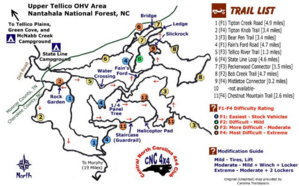
Red arrows indicate the direction I like to run the trails. 4,5 & 6 can be run in either direction. Coming down School Bus can be done but not recommended. Same with Helicopter & Guardrail. There you usually run into too much traffic coming up and it's takes as long to get down as going around 3. Fain's Ford is getting some nice lines to the left coming out of the river. Upper 2 is getting more interesting. Peckerwood step is getting taller. Lower 2 not quite as hard as it used to be. Slickrock getting harder in spots. School Bus is the best and longest. Just my .02.