braxton357
Robot
- Joined
- Apr 6, 2005
- Location
- Morganton
What's the temp there

Kinda like peanut butter jelly..I’ve had (and love) peanut butter whiskey. Screwball specifically, but I never thought of adding cranberry juice. I actually haven’t had it in a while. It was good but a bit sweet. But I could go for some more.
78 during day, 58 at night… PERFECT!What's the temp there

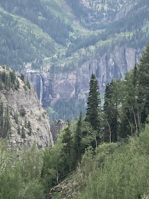
Wheel all the way to MoabThere’s good wheelin in Montrose!!
@89wrangler
We had wheeled there before on one of our Moab trips, good stuff. I am here to check off my bucket lists for Colorado. It is awesome for scenic views and some pucker factors, but not hard wheeling. I have yet to need a locker. We are doing the alpine loop tomorrow which includes engineer pass and some others, should be most of the day. Then on Thursday we are going to hit Poughkeepsie which is supposed to be one of the harder trails. Stay tuned for the report.There’s good wheelin in Montrose!!
@89wrangler
I’m guessing you’re referring to Ouray area trails there from my experience. If you want a hard wheeling trail in CO let me know but you might need a helicopter to get you outI am here to check off my bucket lists for Colorado. It is awesome for scenic views and some pucker factors, but not hard wheeling.
")
I guess i should say challenging, not hard core. You know maybe getting to use a locker or two. I assumed that would be involved with some of the main trails here My hard core days are over. Just want to get out on the trails as much as possible.I’m guessing you’re referring to Ouray area trails there from my experience. If you want a hard wheeling trail in CO let me know but you might need a helicopter to get you out
Glad y’all are having a great trip!