Scenic Drives/Mountain Roads

This thread reminds me of timber ridge trail which is off of the forest serv. road that goes up past edgemont and into Roseborough. I was in that area this spring trout fishing and saw a few motorcycles(dualsports) and 2 jeeps go in/out of this trail and whondered if thats a no no or not. I say this only because some of the old logging roads of the FS road have signs saying "no vehicles" and some don't.:confused:
 
If you're talking about the "road" that cuts to the right before Roseborough and meets 192 at Old House Gap, its shown on my map as an Unimproved Road. If its not posted and its on my Nat Geo map I'd say its open to public travel.
 
Yea thats the one that i think comes out on 221. I asked my dad about it an he said he was pretty sure that was the one they used to ride on everytime it snowed. The one i saw people coming out of was on the left after you cross the bridge. It has the sign on it.
 
It sounds like you have alot more exploring to do in the Brown Mtn./Grandfather area. There are probably close to 200 miles of dirt roads up there. I can hit a dirt road on hwy 181 and come out on hwy 321 just below Blowing Rock without seeing pavement. I've been hiking that area for 15yrs and I still don't think I've been on all the dirt roads up there. Nat Geo has a good map of the area with every dirt road on it. Its the Linville Gorge/Mount Mitchell Trails illustrated map.


bingo. I still find roads up there and bring a map or two just in case. but you're never far from civilization really.

105 from the head of Lake James, takes you up to "the other side of Linville Falls. A couple VERY scenic places. There is a lil pull off on the right going up. You will recognize it by the berms right at the beginning. Walk out there and there is a deck to walk out on, and a rock to climb and look out over the Linville Gorge. The other place is Wisemans View.
MANY roads around these Mnt's
IF you go up 181 from Morganton just before you would turn off to Brown Mnt, there is a road to the left. Sign there says Table Rock. Part of Pisgah NF Many roads to ride in there.
Any of these roads is a good venture. Bring a pic-nic

I believe they call old 105 kistler memorial hwy. nice drive indeed.

Also there are a few roads around west jefferson that are fun to drive.

If you're up for it the road above Brevard is cool because its got about 4 or 5 waterfalls within easy hiking distance. I think it is 276.

Also coming down from lil switzerland is fun any day. Just remember to downshift the auto.

63 west of Asheville is a good paved road at night. downhill of course - never up!

Farther west, max patch and areas around there are nice dippin in and out of TN.

I used to do a lot of 'fun' driving but then gas got high.
I carried a map with me (never looked at it while driving, just turned and drove) When I got home, I highlighted the roads I was pretty sure I was on so I could remember them and even highlighted some that weren't there. :)

I found one the other day that has camping on it similar to Brn mt. -> Curtis Creek. It comes off of the BR pkwy all downhill.

Enjoy it while it last fellas. Gas is 2.40 in Charlotte now.
 
Curtis Creek is indeed a very nice area. One of the few old growth forests left.
 
curtis crk

go to the top of curtis creek then straight across the parkway onto neils creek,follow it to you come to a 3-way intersection take the left fork and follow it past black mt. campground back up to the parkway,follows the south toe river headwaters alot of falls to stop and walk down to and great trout fishing
 
1 of my favs is still Grisseltail over to Long Bottom near Trap Hill. Not as cool now after the crap pave job the state laid down 10-15 years ago, but...

BTW, excellent trout fishing along both, as well as Stone Mtn if your so inclined. Also, the hike over the knob (Stone mtn) is decent and helps fill the day.
 
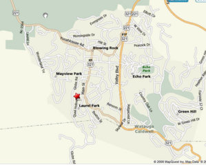
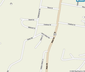
I went out today down Globe Rd to Maple Grove Church Rd. It was nothing more that hard-packed or gravel roads, but it was a great drive especially with the fall colors in the lower altitudes.
Beginning of Globe:
afarm4.static.flickr.com_3037_3008720103_520ba42bda_b.jpg

afarm4.static.flickr.com_3032_3009559906_db35d3e2c2_b.jpg

1/2 way down Globe:
afarm4.static.flickr.com_3164_3008724893_032ea48fc2_b.jpg

afarm4.static.flickr.com_3231_3008730895_8caec299f8_b.jpg
 
nice pics.
Don't forget the other side of the gorge - going to table rock and hawks bill and jonas ridge.
The mile hike to the top of table rock is worth it.

there are soooo many drives I've taken. Its hard to pinpoint just one good one, but the roads coming from the back side of Stone mt is fun. anywhere around the south toe river is beautiful. Transylvania county and Jackson county have some nice ones too. Anywhere around dillsboro.

http://picasaweb.google.com/lorenzo816/SmokieMts#
dillsboro and smokie mts.

http://picasaweb.google.com/lorenzo816/MountainTrip#
194 and around valle crucis

btw this is a great thread to start with the leaves changing and all...
 
Where is Globe rd? Looks awesome id like to check it out
 

Attachments

  • Globe Rd.jpg
    Globe Rd.jpg
    66.5 KB · Views: 238
  • Globe Rd-2.jpg
    Globe Rd-2.jpg
    30.2 KB · Views: 212
Thanks
 
Go to this website http://www.byways.org/ (it's a US-DOT site) and click on the link in the top left corner for "Get your America's Byways Brochure".

The 'brochure' is the National Geographic Guide to Scenic Highways & Byways. 459 pages, 3rd edition 2007.

And best of all, it's free.
 
Go to this website http://www.byways.org/ (it's a US-DOT site) and click on the link in the top left corner for "Get your America's Byways Brochure".
The 'brochure' is the National Geographic Guide to Scenic Highways & Byways. 459 pages, 3rd edition 2007.
And best of all, it's free.

To be honest, this thing was kind of disappointing.

It only has 2 roads for NC, and I already knew about them both.
 
Go get a NC Game lands map or the Trout Fishing Guide by the NC Wildlife. real easy to find BFE with those
 
To be honest, this thing was kind of disappointing.

It only has 2 roads for NC, and I already knew about them both.

You should have scrolled down and looked below the two you already knew about. It looks like there are several more. Some of them don't sound very interesting though. I guess these were aimed at city folks that don't leave the city much.

http://www.byways.org/explore/states/NC/

One of the best maps out there for getting off the beaten path is the Delorme Atlas & Gazetteer.

http://shop.delorme.com/OA_HTML/DELibeCCtdItemDetail.jsp?beginIndex=0&item=258&section=10096

<><Fish
 
Yeah the delorme map is pretty good and detailed.

But I usually pay the price for the $5 or $10 maps that have all the hiking trails, terrain contour lines, and gates for most of the Parks and Forrest in NC. One of the best examples would be the Pisgah Map from national Geographic or the South Toe River Map (sorry can't rmbr who made that one).

I even have a really old map of Linville Gorge that actually has written on the map trails that say "jeep trail". I'll bet closed or overgrown by now and especially since most of the gorge is wildlife refuge - if you drove through there you might get in deep :poop:

The Park system has some good maps at the ranger stations and sometimes gas stations nearby the parks.
 
My wife and I are heading to Boone on Friday evening and staying until Sunday. I'd like to go on some scenic drives. We are staying at my dad's mountain house off of 105-S/Poplar Grove Rd. The house is on the back side of the mountain overlooking Valle Crusis (it's almost directly across the valley from Beech Mtn ski resort.) Location

Any roads nearby I should definitely check out? I bet there's some snow on the ground up there right now. We'll be in my jeep.
 
Globe road and Maple Grove Church are right in the area. Maple Grove is long if you aren't expecting an hour or more ride, but is a great road (well maintained and scenic last time I was through there).
 
Also, Maple Grove has been regraded and regraveled in the past month.
 
I'm thinking about heading up to the mountains this Saturday. As long as I've lived here I haven't really been to any of the site seeing places in the mountains. So, I'm asking yall for help planning this little trip. My truck is currently broke so I'll be driving the Benz and I need to stick with paved roads. :( The less hiking involved the better. Where's the best places to go as far as the views? I'd like to make a loop from Lincolnton (just south of Hickory) to where ever and be back the same day. Would the Parkway be my best bet?

Mt. Mitchell, Grandfather Mountain, Chimney Rock, Linville Gorge/Falls all look pretty cool. A few good places to eat wouldn't hurt either.

Thanks,
Jesse
 
woodlands is some darn good bbq
 
Back
Top