
You are using an out of date browser. It may not display this or other websites correctly.
You should upgrade or use an alternative browser.
You should upgrade or use an alternative browser.
Step 1 To Re-Opening Old Trails - Trail Hike
- Thread starter DRaider90
- Start date
DRaider90
Uwharrie Off-Road Volunteering
- Joined
- Oct 23, 2007
- Location
- Weddington, NC
I have actually hiked some of those old trail beds ..... curiosity got the better of us.
One place to look at is Rattlesnake. Follow it from DB to the end of the ridge. Look for the cross. Seriously creepy.
We have seen a few places that even though they have "softened up" over the years, you can tell they could've been really nasty.
Matt
I would like to hike Rattlesnake at some point, but the only problem with considering it as a trail for re-opening is that its a dead end trail. If we are trying to resolve the issue of Daniel being a dead end trail, its hard to argue for Rattlesnake. The only solution would be to tie Rattle Snake back into Daniel or Gold Mine (if it gets re-opened in some kind of state), or make that section of 555 between cotton place trail head and the end of Rattle Snake part of the trail system like they did to 516 to connect Falls Dam to Wolfs Den. Something to consider at least I guess.
ghost
Well-Known Member
- Joined
- May 25, 2006
- Location
- Hartsville/Camden,SC
I am going to try and make this. I can be at Eldorado's outpost by 9 if i need to be. I can bring the digi camera and the video if needed.
Lrgrnr
Member
- Joined
- May 31, 2010
- Location
- Asheboro NC
I'll be there, but will have to leave by 1 or 2......really looking forward to this.
Stuntman Autoworks
Instigator of things
- Joined
- May 6, 2010
- Location
- Snow Camp NC 27349
I seen this thread too late and already have plans for the 28th but this year I'm not working weekends like I have for the past 2 so I plan on making it out to more things like this and the workdays etc...
- Joined
- Mar 13, 2005
- Location
- Raleigh, NC
I would like to hike Rattlesnake at some point, but the only problem with considering it as a trail for re-opening is that its a dead end trail.
No, this is why I said you just need to go up there with a GPS and hike all over Daniel Mountain and document all the existing roadbeds. I don't see Gold Mine getting reopened -- it ran right up the tributary area for a creek bed on one side, and down the tributary area for a creek on the other side.
But if you document all of the roads in that area, at least then there's a possibility that you can play connect-the-dots and use part of Gold Mine, part of Rattlesnake, part of an undocumented logging road, etc, and get a trail that runs from the Daniel parking lot, up the shoulder on Daniel Mountain (turning more to the south) and hit Dickey Bell somewhere on the north side of Shingle Trap. There used to be a trail that ran from the saddle on Gold Mine right to the top of Daniel Mt. Maybe part of that gets used. Or maybe the trail runs south from the parking lot, parallel to 555, then turns up over the south shoulder of Daniel, on the Shingle Trap side.
Gold Mine Branch is the creek on the east side of the saddle that Gold Mine Trail used to parallel. It flows into a FS-documented 'sensitive area'. The more you avoid that valley, the better.
DRaider90
Uwharrie Off-Road Volunteering
- Joined
- Oct 23, 2007
- Location
- Weddington, NC
No, this is why I said you just need to go up there with a GPS and hike all over Daniel Mountain and document all the existing roadbeds. I don't see Gold Mine getting reopened -- it ran right up the tributary area for a creek bed on one side, and down the tributary area for a creek on the other side.
But if you document all of the roads in that area, at least then there's a possibility that you can play connect-the-dots and use part of Gold Mine, part of Rattlesnake, part of an undocumented logging road, etc, and get a trail that runs from the Daniel parking lot, up the shoulder on Daniel Mountain (turning more to the south) and hit Dickey Bell somewhere on the north side of Shingle Trap. There used to be a trail that ran from the saddle on Gold Mine right to the top of Daniel Mt. Maybe part of that gets used. Or maybe the trail runs south from the parking lot, parallel to 555, then turns up over the south shoulder of Daniel, on the Shingle Trap side.
Gold Mine Branch is the creek on the east side of the saddle that Gold Mine Trail used to parallel. It flows into a FS-documented 'sensitive area'. The more you avoid that valley, the better.
I didn't say we wouldn't hike Rattle Snake at some point, if you remember I agreed earlier in this thread that we should document as many road beds as possible. But its a process we need to take one step at a time. It would be awesome if we could use Gold Mine, then cut "down" the side trail that goes up Daniel Mnt. and connect it down to Rattle Snake etc. But that is all speculation until we get out there and start documenting the trails.
I simply stated my opinion on Rattle Snake as of right now seeing that its a dead end trail. After we hike Gold Mine, we can focus on another trail, such as Rattle Snake. Having someone with a background in hydrology, plus one of the people that helped form the OHV Trail System as it is today will be vital in gathering information and then making decisions from there. I want to make sure that we cover all our bases and get everything we need documented as we go along taking it one step at time.
It's been many years, but I think I rode CCC Trail in the very early 90's. If it's the one I recall, they is a big flat slab on the climb as you climb onto 516. I know that I rode two trails off the side of 516 back in the day. The other one must have been Old Falls Damn, because it came out of the Overflow campground at the top of the 576. If you came up 576 into the meadow, it ran out of back left corner.
DRaider90
Uwharrie Off-Road Volunteering
- Joined
- Oct 23, 2007
- Location
- Weddington, NC
It's been many years, but I think I rode CCC Trail in the very early 90's. If it's the one I recall, they is a big flat slab on the climb as you climb onto 516. I know that I rode two trails off the side of 516 back in the day. The other one must have been Old Falls Damn, because it came out of the Overflow campground at the top of the 576. If you came up 576 into the meadow, it ran out of back left corner.
If you take a look at this map you will see where the 3 old trails run over on that side of the map:
http://img710.imageshack.us/img710/7421/newandoldtrails.jpg
The CCC Trail, Big Branch Trail, and an Old Section of the Falls Dam Trail sit over in that area. The Forest Service is using parts of those trails plus new sections to create the "Lake View Trail" that will be opening in October. They have been talking about re-opening trails on that side of the map since Deborah Walker became the head ranger at URE. So its nice to finally see it come to fruition.
The end goal of this is to get what ever trails we can re-opened, this includes hiking as many old road beds as we can. But for the first hike we are focusing on Gold Mine, and if we have time at least locating the entrance to Rattle Snake. Because the hike will be more than just walking the trail, we be stopping to document as much as we can, taking pictures, notes etc.
I am going to try and make this. I can be at Eldorado's outpost by 9 if i need to be. I can bring the digi camera and the video if needed.
Hope you can make it out. Anything you can bring will be of a help including cameras etc.
To everyone else that has show interest in this and/or plans on coming out I am looking forward to working with everyone on our first hike. If you can't make this hike there will be more, and workdays, and plenty of other opportunities to help out at URE.

Lrgrnr
Member
- Joined
- May 31, 2010
- Location
- Asheboro NC
Can we start our trec around 9 or 9:15? I would love to be out of the woods by 1 or 2. If we don't get started till around 10 or 10:30 then that means we will not get out till 4 or later.
This looks like a pretty long mountainous hike. So everyone don't forget water and maybe a snack for lunch.
I myself will be there between 8:30 and 9 and will be ready to roll by 9:15.
This looks like a pretty long mountainous hike. So everyone don't forget water and maybe a snack for lunch.
I myself will be there between 8:30 and 9 and will be ready to roll by 9:15.
DRaider90
Uwharrie Off-Road Volunteering
- Joined
- Oct 23, 2007
- Location
- Weddington, NC
Can we start our trec around 9 or 9:15? I would love to be out of the woods by 1 or 2. If we don't get started till around 10 or 10:30 then that means we will not get out till 4 or later.
This looks like a pretty long mountainous hike. So everyone don't forget water and maybe a snack for lunch.
I myself will be there between 8:30 and 9 and will be ready to roll by 9:15.
I have been told its not that long of a hike, we will see. We should only have to hike the trail one way if we coordinate it correctly. Drop off one or two vehicles at the Dickey Bell entrance where Gold Mine comes out, load people up in the vehicles then drive back to the Cotton Place Parkinglot where the rest of the vehicles are. Taking 10-15 minutes to get people transported back to Cotton Place via vehicle is a lot better than a couple hours hiking back down the trail.
Lrgrnr
Member
- Joined
- May 31, 2010
- Location
- Asheboro NC
I think you are right......I was thinking it climbed up Daniel mtn but instead it looks too stay in the valley with one climb about mid way.
Also looks like a trail cuts off and goes to the top of Daniel mtn going by this map with elevation.
[/IMG]

Also looks like a trail cuts off and goes to the top of Daniel mtn going by this map with elevation.
[/IMG]
88bronzetrooper
Well-Known Member
- Joined
- Feb 19, 2009
- Location
- Fort Mill
Hey Eli looks like Dad and I will be there and maybe Alex and shannon. But i am just getting a handle on what were doing. Are you just wanting to hike goldmine trail or can we do maybe two trails? Like maybe rattlesnake as well just to see what it looks like. I think with the amount of cameras coming and gps units maybe split into two groups?? I dont know just throwing ideas out there. With the time needed and equipment we have seems like we could do more then one trail in a hike even with documenting whats there. I will have my video camera and Dad his Nikon.
ghost
Well-Known Member
- Joined
- May 25, 2006
- Location
- Hartsville/Camden,SC
Still planing on coming up Saturday morning. Should be at the outpost around 9 or 9:30. Is that good? I will have my point and shoot and can bring video camera if needed.
drkelly
Dipstick who put two vehicles on jack stands
- Joined
- Mar 21, 2005
- Location
- Oak Ridge/Stokesdale, NC
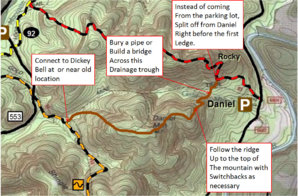
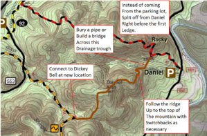
Looking at that topo map, the old Gold Mine trail seems to follow the drainage path down both sides of the mountain. I don't remember a great deal about that trail since it has been so long since it was closed. I'm guessing building a trail down a drainage path is considered bad trail design due to erosion from water run off.
Fooling around during my lunch hour, I sketched up a couple of paths that seem possible and reasonable to avoid watershed problems.
Fooling around during my lunch hour, I sketched up a couple of paths that seem possible and reasonable to avoid watershed problems.
Attachments
K45
Active Member
- Joined
- Feb 21, 2007
- Location
- Statesville
At 1st glance the trails you are showing are great. you will not be able to get away with a pipe crossing that is such a large drainage area coming down to a point. you can probably get away with a large open bottm box culvert or bridge. Alot of this trail layout stuff will be determined on how difficult you are wanting the trails to be. It looks like the gold mine trail was a poor design and definitely will not cut it with todays standards without a ton of bmps. I am looking forward to this weekend. we do need to iron out the time and place. i am cool with 9 at the outpost.
88bronzetrooper
Well-Known Member
- Joined
- Feb 19, 2009
- Location
- Fort Mill
Im good with 9am at the outpost. ANd get on the trail by say 930?
drkelly
Dipstick who put two vehicles on jack stands
- Joined
- Mar 21, 2005
- Location
- Oak Ridge/Stokesdale, NC
At 1st glance the trails you are showing are great. you will not be able to get away with a pipe crossing that is such a large drainage area coming down to a point. you can probably get away with a large open bottm box culvert or bridge. Alot of this trail layout stuff will be determined on how difficult you are wanting the trails to be. It looks like the gold mine trail was a poor design and definitely will not cut it with todays standards without a ton of bmps. I am looking forward to this weekend. we do need to iron out the time and place. i am cool with 9 at the outpost.
I think most people would like the trail to be fairly difficult.
After seeing the new Sawmill trail though, I think the Forest Service probably has a different opinion. They basically skirted the side of the mountain providing as little elevation change as possible which makes for a VERY boring trail.
- Joined
- Mar 13, 2005
- Location
- Raleigh, NC
You just need to double those whoops.
TJcrawler97
Joe
- Joined
- Oct 12, 2006
- Location
- Charlotte
Looks like I'll be there. Eli any word yet on a 4x4 or atv being close by for emergencies. So what's the word on gps? Does the group have them. I was going to download a app but didn't know who all was bringing what. Is a accurtrail or anyother worth the $
DRaider90
Uwharrie Off-Road Volunteering
- Joined
- Oct 23, 2007
- Location
- Weddington, NC
we do need to iron out the time and place. i am cool with 9 at the outpost.
I think I have it posted in the first post, plus another one along the way we will be meeting at the Eldorado Outpost at 9AM. Group up, maybe grab a quick breakfast and plan on getting to Cotton Place around 9:30AM.
Hey Eli looks like Dad and I will be there and maybe Alex and shannon. But i am just getting a handle on what were doing. Are you just wanting to hike goldmine trail or can we do maybe two trails? Like maybe rattlesnake as well just to see what it looks like. I think with the amount of cameras coming and gps units maybe split into two groups?? I dont know just throwing ideas out there. With the time needed and equipment we have seems like we could do more then one trail in a hike even with documenting whats there. I will have my video camera and Dad his Nikon.
Maybe I am missing something but I am only seeing one confirmed GPS. Like I said maybe I missed something, but I am figuring until we get everyone together and see what equipment actually shows up we won't know how many trails we will be able to hit. If we have enough equipment then sure we could split up and do Gold Mine plus Rattle Snake. Just depends on who all will be there, and with what gear.
Looks like I'll be there. Eli any word yet on a 4x4 or atv being close by for emergencies. So what's the word on gps? Does the group have them. I was going to download a app but didn't know who all was bringing what. Is a accurtrail or anyother worth the $
The initial response I got was not very likely as far as having a vehicle or ATV on the trails. I will be getting the final answer either tomorrow or Wednesday and will post up for definite then.
88bronzetrooper
Well-Known Member
- Joined
- Feb 19, 2009
- Location
- Fort Mill
Ok guys lets get a list going of whos confirmed to go.
88bronzetrooper + 1 (+2 more are maybe) SLR and Video cam
88bronzetrooper + 1 (+2 more are maybe) SLR and Video cam
DRaider90
Uwharrie Off-Road Volunteering
- Joined
- Oct 23, 2007
- Location
- Weddington, NC
Ok guys lets get a list going of whos confirmed to go.
88bronzetrooper + 1 (+2 more are maybe) SLR and Video cam
Only problem with a confirmed list etc is you never know until the day of. People can't make it last minute etc etc, and some people show up last minute. We just won't know until we get there, trust me I have learned this first hand with the workdays.
I got the final answer on the emergency vehicle/atv, that is a no go. So we will just have to make sure we take it slow, be extra careful, wear bright clothing, and just be safe.
K45
Active Member
- Joined
- Feb 21, 2007
- Location
- Statesville
I can bring my trama 1st aid kit and everyone needs to bring water.
88bronzetrooper
Well-Known Member
- Joined
- Feb 19, 2009
- Location
- Fort Mill
The confirmed list still helps get any idea Eli. I mean yeah people may show up last minuet and people may bail last minuet but that doesn't mean we cant at least get an idea of whos going and not going to help us be better organized.