rodney eppes
Well-Known Member
- Joined
- Feb 3, 2010
- Location
- Mt.Holly NC 28120
New Sport > Tree Surfing!Just your normal neighborhood "those guys" doing stuff

New Sport > Tree Surfing!Just your normal neighborhood "those guys" doing stuff

I'm sure you had to deal with this - it also becomes a question of "safer to evacuate or keep everybody here in one piece?"Dude...I evacuated the plant yesterday while there was a break in the red bands, tornado protocol was not fun. From what I'm seeing we had upwards of 3 funnels touch down within a 15 mile radius. Fortunately, my house was damage free, but the flooding and damage I've seen driving around was pretty intense.
I'm sure you had to deal with this - it also becomes a question of "safer to evacuate or keep everybody here in one piece?"
View attachment 311813
Flood got my favorite camera
Water line is just under the lens, about 3.5' up a tree, 80yds from the river. Usually a 6-7' bank at the river. The water lines on the trees were 3-4' in the bottom. I figure the river was 10-12' over normal. I'd have some interesting pics if I didn't leave my phone at home or I could get the sd card to play
If its all solid state, I would definitely set that thing in a big bag of rice for a day or so, and do NOT turn it on. The SD card is probably fine at least.Wonder if the bag of rice treatment would work? Seems like the SD card should work if dry and put into a computer or something? I’d really like to see those pics!
They said the South Fork was about 17ft over normal.If its all solid state, I would definitely set that thing in a big bag of rice for a day or so, and do NOT turn it on. The SD card is probably fine at least.
Water is only really a problem for electronic when they are on/current is flowing.
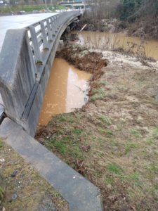
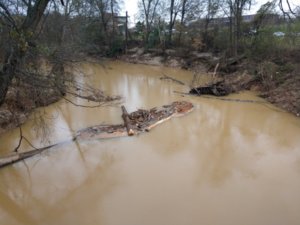
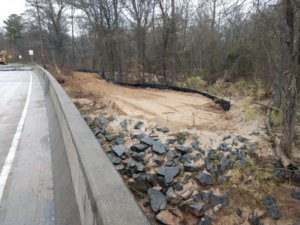
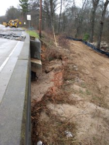
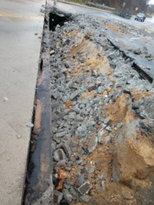
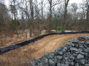
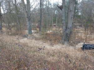
Son of a bish. I was wondering why it was still closed. That's really F'd up my commute home Friday and today.Took these late today. Hwy 73 in Mount Holly, 4 lane bridge over Dutchmans Creek, before it pours into the Catawba. Happened sometime Thursday, but was Saturday before I heard of it. I've been here 21 years & we've had at least 3 "100" year Floods. This bridge has never been damaged or overflowed, before. Guess it had More Blockage this time. Washed out under the north end. Sand wash, as far up & over the banks as I've ever seen it! Picture of the field & trees, with a red looking line, is the water line, which would also be road level. With the Catawba being Full, may have backed this creek up, too! 1/2 of the washed end top cover has been torn off. Probably the other have will be too, to back fill it. How Long for repairs? Hwy 73 & Hwy 27, are the Main arteries of Mount Holly!
Finally today, I see Spectrum & Channel 9, reporting the Flooded Apartments in Mount Holly. Ch.9 only covered the apartments, as far as I know, where Spectrum news, covered the apartments & the damaged bridge. I was in a restaurant & the sound was muted, so I don't know what the story/time line, is on the Bridge. State did work on it today, including hauling Class A [BIG] rip rap.Holy Water! Like I said, That Ain't Never happened! I didn't check the River, last week, since we only only had 3-4" of rain, over a long stretch. but That makes me think the Catawba, Backed up Into the Creek!
Mount Holly update today. Dropped by after the workers were gone. Creek is down some, but still running Strong, & Same debris still there. West side where the washout started, I got down low as I could, & viewing the steel pilings exposed about a foot. I would think the concrete end support, Should be touching the ground. Water/mud mix still in the hole. On the east side, a pump is running, pumping into a bladder. The bladder is slowly releasing water, back to the Creek. No idea on the purpose of this? Maybe some hydrologist has an idea? East side is also washed out More than the West side, showing More piling & concrete wall, in the air. About 50+ feet of pavement has been removed, & some of the dirt/stone, has been pushed into the void. A Lot of crusher run & some #57 or #5 stone, hauled in. Along with maybe 4 loads of Class B Rip Rap. State Is working on it, at their usual pace.
[I'm watching the Daytona Dual Qualifiers]
It's working! If you can see wave looking lines on the bag, that's the lines of water flowing out of it. Only, with the sediment, high water, & debris, still in the water, I don't see the use of the bag!The bag is a geotextile bag. It is meant to filter out the sediment before the water goes back into the river.
It's working! If you can see wave looking lines on the bag, that's the lines of water flowing out of it. Only, with the sediment, high water, & debris, still in the water, I don't see the use of the bag!

