Uwharrie OHV Trail Map

Thanks DRaider
No problem. I went back to fix one thing I forgot to update and ended up adding a couple more things. So if you have all ready downloaded it, there is a slightly tweaked version there now. (Same Link)
 
Is there an updated map?
 
Gonna bump this back up, any map with the new trail on it?
 
shows how slow things really are with the Govt when lake view is on Eli’s early map saying “2012”!! :laughing: 
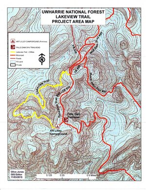
Even the Badin lake ohv trail map still says Kodak Rock is there and the upper section of RmL.

I could honestly make a new version of this in Illustrator fairy quickly even without Eli’s original and include the lake view trail.

With all the gps/carto apps, is it necessary? What features on this map made it so great? The obstacle call outs?
What would be important? I’ve actually always hated this map as from a “what’s important to read” on the map it’s visually busy as snot and hard to read and even harder to read at night. Truthfully I havenot used a map in uwharrie in maybe 10 years except to argue over which direction to go. 🤠
 

Attachments

  • IMG_2503.jpeg
    IMG_2503.jpeg
    350.9 KB · Views: 102
I'm just used to the old map. I do like the obstacle call outs, trail distances and up/down directions. It's nice for planning out routes. I haven't joined the current decade of gps apps, so there may be something better that has all of this and more already. Right now I can pull up a georeferenced version of it in the Avenza app on my phone if I want to roughly see where I am on a trail, and I probably have it printed in the glovebox too.
 
I want to go a ride my xterra 4x4 but is a stock car, what will be the best trails for my car?? Any sugestions?
Come out on one of the events or link up with some fb groups. Like Noas. Your truck can do 80% of the park truthfully and you’ll have fun.
 
Back
Top