telemike
Trail Rider
- Joined
- Apr 23, 2009
- Location
- Greensboro
I did not see any animals on fs187 :-( I plan on going back when the leaves change color
Sent from my Nexus 7 using Tapatalk 4 Beta
Sent from my Nexus 7 using Tapatalk 4 Beta

I looked in my book of maps and found it.You can access it by coming off of Edgmont Rd. southeast of Grandfather Mountain.Closest communtitee is Gragg.Actually it looks like it comes out at Roseborough.
I looked in my book of maps and found it.You can access it by coming off of Edgmont Rd. southeast of Grandfather Mountain.Closest communtitee is Gragg.Actually it looks like it comes out at Roseborough.
Nothing much left but gravel roads. Mountain bikers get all the gated trails now
Sent from my XT907 using Tapatalk 4 Beta
Ok just so you guys don't think I'm trying to turn this thread into a different direction ill start out with adding two roads. Peppers creek runs from North Cove in McDowell across from Baxter's up behind Walmart in spruce pine it's not very long but its all gravel has some killer views and its a nice way to get up to the BRP. And then Curtis creek goes from old fort up to the parkway its about 10 miles mostly gravel very scenic and a few nice streams run next to it. Ok so my question is about Sampson road this is the first I have heard about it and I'm wandering what to expect is it like 105? Looking at it on Google maps it looks like I can get to it straight off parkway is this correct or do I need to access it differently? Thanks and great thread idea I love all of our gravel roads and Forrest service roads we have to offer sometimes you just have to know where to look.
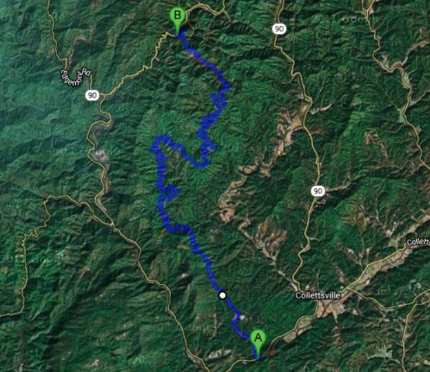
Please note this road has HEAVY TRAFFIC during bear hunting season. Please be aware of empty trucks with dog boxes. This route is also known as Maple Sally on the lower end, and Maple Grove on the upper end.Forest road 187 in Pisgah National Forest North Carolina.
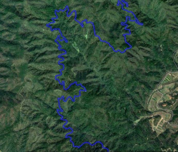
Amazing 18 mile long one lane dirt road that follows a Ridge line. Lots of twists and turns, going up and down and all around. Some great overlooks on the mountains. Only saw some bikers, couple trucks logging and a lost minivan.
The route:
http://goo.gl/maps/cTR6x


tell me more of your trip.What time and where ya'll are meeting.How long of a drive.EtcAugust 17th, some of us Expedition Portal members are meeting in Wilkesboro and heading down some back roads
Sent from my XT907 using Tapatalk 4