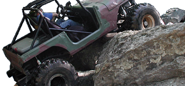
The old Tellico revisited...... Picture heavy!

ghost

Well-Known Member
Joined
May 25, 2006
Location
Hartsville/Camden,SC
So I was in Hayesville, NC recently and decided I wanted to see the old Tellico and see if trail one was truly paved......

Here is a map for those of you that never had the privilege:


ai16.photobucket.com_albums_b25_xjghost_Hayesville__20Murphy_2c9e4385cea11727ff99609e5bd741fe3.jpg


Part of what is the trail 1 road:


ai16.photobucket.com_albums_b25_xjghost_Hayesville__20Murphy_2059421b29f1c5d2eb6f6f18dc92631f1.jpg


I see now why they wanted to do what they did:

This is not in the Forrest but on the road/ trail 1 leading to the pay station.


ai16.photobucket.com_albums_b25_xjghost_Hayesville__20Murphy_2d28d610e86ed38dc7a8be562a11fab8c.jpg


The old pay station and parking lot:


ai16.photobucket.com_albums_b25_xjghost_Hayesville__20Murphy_2248e80df7a0143a58dc5fce90da0525a.jpg


ai16.photobucket.com_albums_b25_xjghost_Hayesville__20Murphy_2fad652dc5aadcccc2e1ef21d1a03ed34.jpg


This power box is almost exactly where they old pay sign use to be:


ai16.photobucket.com_albums_b25_xjghost_Hayesville__20Murphy_25cf986798f2ce064ca22d44e844407f9.jpg[/URL
]
 
Entrance to upper 2:


ai16.photobucket.com_albums_b25_xjghost_Hayesville__20Murphy_21b28d460f88a44004c47b5dccbe03386.jpg


I can remember lining up and looking out the driver window and seeing this:


ai16.photobucket.com_albums_b25_xjghost_Hayesville__20Murphy_24cae31227612ba2a6b19eff144cff269.jpg


Part of this trail actually is on private property:


ai16.photobucket.com_albums_b25_xjghost_Hayesville__20Murphy_2ad0d7b6fed1749efb3dd75320870c2a6.jpg


The climb in. This was clearly filled in at some point or scrapped over. It was a rocky steep hill climb back in the day.


ai16.photobucket.com_albums_b25_xjghost_Hayesville__20Murphy_2533e26b8d8a338386d86162c84b87c47.jpg


This is where the Forrest land starts. You can see they pilled trees and stuff in the trail. I did not go in any further then here on this trail.


ai16.photobucket.com_albums_b25_xjghost_Hayesville__20Murphy_2e7076fb36bfe563901ad364eaa7ee53e.jpg


ai16.photobucket.com_albums_b25_xjghost_Hayesville__20Murphy_29a34170d996b266fb679e4db2bc52bbf.jpg[/URL
]
 
Entrance to trail 4: It is here I got my first introduction to what a great group we have at NAXJA. In '02 I attended my first Crawl with an 84 xj on 33's. It ran fine when I left but here it was backfiring like crazy. GaMike and A-Mechanic would not let me return to camp and escorted me with the easy group. They moved on up the trail and the three of us ran together and actually kept up. Been in love with wheeling and this club ever sense.


ai16.photobucket.com_albums_b25_xjghost_Hayesville__20Murphy_2ae3ca60bac0268fa0737c79175e907fd.jpg


Remints of a trail marker:


ai16.photobucket.com_albums_b25_xjghost_Hayesville__20Murphy_2fcd2ccbd91eaaabb79ce94ddb332c6e1.jpg


Trail 4 was an easy trail by Tellico standards but it was rocky and rough:


ai16.photobucket.com_albums_b25_xjghost_Hayesville__20Murphy_290a744abea626af9a677f58d2147468f.jpg


ai16.photobucket.com_albums_b25_xjghost_Hayesville__20Murphy_234c6d3528fe477d5625cd1c6226a41f9.jpg[/URL
]
 
Trail 1:


So yes part of it is paved:


ai16.photobucket.com_albums_b25_xjghost_Hayesville__20Murphy_2eb750def388e191c2404ba390dfca92a.jpg


ai16.photobucket.com_albums_b25_xjghost_Hayesville__20Murphy_2b7b37efed8936c44f78813ab6a284293.jpg


ai16.photobucket.com_albums_b25_xjghost_Hayesville__20Murphy_29e4bc023ddb78290e8ec661c63cb1c59.jpg


My wonderful girlfriend Deanna that went on this adventure through memory lane with me: This is the bridge right at the entrance to Lower 2.


ai16.photobucket.com_albums_b25_xjghost_Hayesville__20Murphy_24c9c2b108ff81b8583fd5b7a7a33e89b.jpg


The Tellico river I believe:


ai16.photobucket.com_albums_b25_xjghost_Hayesville__20Murphy_260586261defd131a2f73a536cf400de5.jpg


ai16.photobucket.com_albums_b25_xjghost_Hayesville__20Murphy_22b4156abf76e37a3b3f488afa9174b3b.jpg


The VW is sitting in the entrance to trail 2: The gate was open too..... No I did not go down it. It was getting late.


ai16.photobucket.com_albums_b25_xjghost_Hayesville__20Murphy_279567f9ff289ea35feb63c4b971fdc16.jpg[/URL
]
 
Trail 5 entrance and where trail 6 came out:


ai16.photobucket.com_albums_b25_xjghost_Hayesville__20Murphy_2ee7b7eeb73f29658c7b57022c4365353.jpg


ai16.photobucket.com_albums_b25_xjghost_Hayesville__20Murphy_24d81442d2df66e3cf0221dd1e992957d.jpg


So trail 5 now. this trail was navigable by a stock 4wd and people often towed up to the Tellico river crossing and camped there:


ai16.photobucket.com_albums_b25_xjghost_Hayesville__20Murphy_2c2f7809ff104ec32e28fcd4f715f6f38.jpg


This trial ran right next to the river and was a beautiful drive:


ai16.photobucket.com_albums_b25_xjghost_Hayesville__20Murphy_25c92d01682be0fbd256be9fd91fa6aff.jpg


These signs were all along where trail 5 was very close to the river:


ai16.photobucket.com_albums_b25_xjghost_Hayesville__20Murphy_21cdae4bc7ca522af1438cb76d6569f4d.jpg


Hmm....


This is the spot that we use to cross the Tellico river. It was a river crossing. One of the attempts to keep Tellico open was that S4WD built a bridge over it and proposed to build a second at Fain's Ford.


ai16.photobucket.com_albums_b25_xjghost_Hayesville__20Murphy_280f71eb6df934ec19d3e472d3681b700.jpg


The bridge in the middle of the forest....


ai16.photobucket.com_albums_b25_xjghost_Hayesville__20Murphy_2bf50b13c0b380627798f9f2efdbb2325.jpg


The old exit. This was a nasty climb out back then.


ai16.photobucket.com_albums_b25_xjghost_Hayesville__20Murphy_29e84910d84ad4f27dd3a6cf05070f63b.jpg


View from the bridge:


ai16.photobucket.com_albums_b25_xjghost_Hayesville__20Murphy_269a629c0808e6dd4a5b738c404cac143.jpg


Down river:


ai16.photobucket.com_albums_b25_xjghost_Hayesville__20Murphy_2f31fd016d705f7d68f1b03690417452a.jpg


Trail 5 on the other side of the bridge:


ai16.photobucket.com_albums_b25_xjghost_Hayesville__20Murphy_2dc2ca760cca262f311a139ff615ac2a6.jpg


This was a popular place to primitive camp back in the day:


ai16.photobucket.com_albums_b25_xjghost_Hayesville__20Murphy_20434d4eb099aa7cc30dbbe2e8edab4ae.jpg


The right is the old trail 5 filled with trees and vegetation:


ai16.photobucket.com_albums_b25_xjghost_Hayesville__20Murphy_27916e6a28916378e3a7deba06a1c5db3.jpg


Trash found a half hour walk into the woods where 4x4's haven't been in years!


ai16.photobucket.com_albums_b25_xjghost_Hayesville__20Murphy_20c64aa031daf6b412e532a6fffc86faa.jpg
 
The campground was there the final trip I took which was closing week. I drive thru there when I'm in town. Sad sad.
 
Memory lane indeed. Thanks for posting this.
Campground looks the same to me.

Last time I was there, the 250k bridge didn't exist.
 
Last edited:
Never went, actually missed out on a trip due to work, wish I would have known that was my last opportunity to ride there. Thanks for the pics.
 
Memory lane indeed. Thanks for posting this.
Campground looks the same to me.

Last time I was there, the 250k bridge didn't exist.

One of my best memories of being there was the trip we took and the Ranger came by when we were cooking and rather intoxicated. He basically told us we needed to make sure all of our food was put up cause there had been a bear siting which we knew because there was a print right beside of our tent. In our drunkin state we thought it would be a good idea to set my grill on the Hundley's windshield that was folded down over night. Guess we thought a bear couldn't reach the hood of his CJ which is clearly drunk logic. We must have cooked 20 burgers on the grill therefore; Hundley had 20 burgers worth of grease and fat pooled in his windshield the next morning. We rode Robbinsville on the way home (having a run in with some more law) and the passenger side of Hundley's windshield looked like a damn shower door it was so cloudy.
 
Thanks for the pics..

If anyone wants to see what the trails looked like before they were closed I have a bunch of Tellico pics here:

http://s1069.photobucket.com/user/goallout/library/Tellico?sort=3&page=1

Here:
http://s1069.photobucket.com/user/goallout/library/Tellico ride with cnc4x4?sort=3&page=1

and Here:
http://s1069.photobucket.com/user/goallout/library/Tellico with Xtreme 4x4 TV?sort=3&page=1

Guard Rail:
ai1069.photobucket.com_albums_u477_goallout_Tellico_20ride_20wd11ccfc3924004ede83cc8fa99c04cc7.jpg


Helicopter Pad:
ai1069.photobucket.com_albums_u477_goallout_Tellico_20ride_20w6b9ff73b38a65efae3d0f0c27da74e43.jpg


ai1069.photobucket.com_albums_u477_goallout_Tellico_20ride_20w349cdc4318728483177e8e3f69fadddb.jpg
 
Thanks for taking the time to post and upload the pics @ghost and @BRUISER
Its embarrasing what "OUR" government and representatives call natural, and amazing how quickly the forest rebounds and recovers the lost ground.
 
Would be nice to see some before and after pics side by side, went through there one time but never really got to wheel it. I would have loved to gone at least once.
 
One of my best memories of being there was the trip we took and the Ranger came by when we were cooking and rather intoxicated. He basically told us we needed to make sure all of our food was put up cause there had been a bear siting which we knew because there was a print right beside of our tent. In our drunkin state we thought it would be a good idea to set my grill on the Hundley's windshield that was folded down over night. Guess we thought a bear couldn't reach the hood of his CJ which is clearly drunk logic. We must have cooked 20 burgers on the grill therefore; Hundley had 20 burgers worth of grease and fat pooled in his windshield the next morning. We rode Robbinsville on the way home (having a run in with some more law) and the passenger side of Hundley's windshield looked like a damn shower door it was so cloudy.

Don't know if it's the same night or not, but I recollect an evening when Dylan & Hundley were cooking/reheating BBQ by a small stream that was full of bear tracks. I seem to remember them being in a "far away" different location next morning. :lol:
 
I have very few regrets in life... but one of them was that I never went there. was always "too far away".
Now I travel almost that far every time I want to wheel.
 
Thanks for the pics....I was lucky enough to go twice, riding shotgun with Mike - aka Broncomania.

The views were awesome & trails challenging.....shame.
 
What a ride down memory lane. One of the reasons I moved to NC is Tellico. My club used to come down here every spring to ride and then I moved and the bastards closed it down. I've many a times thought about taking a ride out there and hiking around. Does anyone know if Chuck still has the rental cabins right there. I had many a good times in those cabins and on his private rock pit.
 
The last time I was there me , bud from budbuilt and Toyota dad took on lower 2. Cant remember the other folks on that trail, but it was a blast!
 
I think we should all make the trip to durhamtown tellico this yr to let them know we want the place to develop more. Myself and others had a trip planned but things happened that kept us from going. All I hear about the place is there's not much there obstacle wise, well there won't be if no one goes. And for all that used to wheel Tellico you know you could ride most of the place in 2wd until you got to one of the obstacles, of which you could count on both hands.
 
Back
Top