Here come the hurricanes!

We got back to Charleston last night. Doesn’t look like much of anything happened while we were gone other than no mail was delivered for a week.

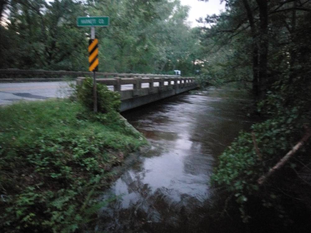
First pic is the ditch behind our house from a random rainy day in July this year....Second pic is the same ditch this morning after getting back from our mandatory evacuation.

8F01205C-CC35-4892-9AF0-E168A18585D4.jpeg
E33245FA-7ADA-4063-9E07-BDDE02C93132.jpeg
 
Just went from Winterville to Cedar point.... all through havelock nothing but trees down on power lines. Traffic backed up 2 miles for fuel at the gas stations
 
I’m just outside of Atlanta and headed to Aberdeen in the morning. The map is taking me from Camden up cross lots to Rockingham. Any issues through that neck of the woods. I have tried the ncdot page and it doesn’t show any closures except around on some side roads in cheraw. Any advice?
 
I’m just outside of Atlanta and headed to Aberdeen in the morning. The map is taking me from Camden up cross lots to Rockingham. Any issues through that neck of the woods. I have tried the ncdot page and it doesn’t show any closures except around on some side roads in cheraw. Any advice?
Cheraw and Chesterfield got hit pretty good. My mom teaches in Chesterfield. Schools are still out. Hopefully gps is updated for you. Wish I could help you more. I’m thinking highway 1 in Cheraw will be an issue. Potentially side roads near the river in Rockingham but you shouldn’t need to travel those. Once you clear Rockingham on 1 you should have smooth sailing all the way to Southern Pines.
 
They are releasing water into Black Creek today from the Nuke plant and also Prestwood Lake which is the lake below it.. Anyone South of us Along Black Creek is about to get a shit tone of water. I've been watching Lynches River rise steadily over the last two days too.
 
The Deep River on us421 just north of Sanford is almost to the road. If (as soon as) it touches the white line, DOT is going to shut the road down.


Sent from my SM-G930V using Tapatalk
 
15-501 between Sanford and Pittsboro is now closed at Deep River (county line Lee/Chatham)

Sent from my SM-G930V using Tapatalk
 
Little river on the north end of spring lake has 24/87 closed. I don’t know what is getting rerouted but the traffic on 211 between Raeford and Aberdeen is re-fucking-diculous!
 
Little river on the north end of spring lake has 24/87 closed. I don’t know what is getting rerouted but the traffic on 211 between Raeford and Aberdeen is re-fucking-diculous!
I think that's pretty much the only way to Fayetteville from the north (Sanford area) right now. 24/87 is closed in Spring Lake, the little white church they keep showing on the news at that intersection is where my Great grandparents are buried, the motel across the street collapsed. That's not far from my house, maybe 5 or 6 miles upriver. 210 is closed in Spring Lake on the little river too. 401 was closed between lillington and fayetteville at the upper little river, and it was about to overflow the bridge on the little river too but I don't think it did. All the backroads around my house got flooded too do you can't even detour the main roads. It doesn't help that the Little River is the Harnett/Cumberland county line.

I took the picture last night at the Little River a half mile from my neighborhood. This is a few miles down river from 24/87. The river is usually about 30 feet across and it's usually about 25 or 30 feet below this bridge. That's as high as it got during Matthew. Today the Highway Patrol shut the road down and barricaded it because the water was 2 or 3 feet over the asphalt and it's flowing hard. I saw a report from the usgs river gauge that said the mean flow on the river was 500 cf/s it was 11500 today! Where I stood to take that picture last night was about waist deep today.
061a6b649e8da2b05ee1a4f79309074c.jpg


Sent from my HTC6545LVW using Tapatalk
 
Damn! @Tim C it’s so crazy cause I was so worried about driving into the state but is was a non issue. I’m staying with a buddy in Raeford on the 401 business. Things here look like nothing happened. I have been up to Aberdeen and same there but then I hear all the madness over towards Fayetteville and it’s hard to fathom how regional this all is
 
Damn! @Tim C it’s so crazy cause I was so worried about driving into the state but is was a non issue. I’m staying with a buddy in Raeford on the 401 business. Things here look like nothing happened. I have been up to Aberdeen and same there but then I hear all the madness over towards Fayetteville and it’s hard to fathom how regional this all is
Yea looking at the rainfall totals the farther west you go from fayetteville the less they got so the flooding wasn't as bad in southern pines for example Vs the east side of fayetteville where they got over 20" of rain.

A friend / customer at the shop where I work lives on the other side of the bridge in that picture by a few miles, and he was stranded at home today. The upper little river, the little river and Anderson creek box him in a triangle of flood water. He was on an island til it receded. The water is down below the bridge again but I think they're going to keep the road closed until they can inspect the bridge supports for erosion.

I heard but can't confirm that us13 and NC 24 on the east side of town have washed out and are impassable flood waters or not.

Sent from my HTC6545LVW using Tapatalk
 
One picture is the church I was talking about. The road to the right of it is 24/87 looking from spring lake to Sanford. This is the corner of 24/87 and Manchester road. The second pic is the starlight motel, it was a rinky dink roach motel, diagonally across the intersection from the church. The little river usually runs behind the motel and like by my house its 20 or so feet below the bridge and only 20 to 30 feet wide with a depth of maybe 10 feet max. You can see where several rooms from the motel have washed away. There's part of a room at one end then the main lobby part with nothing between.
72b910ed6d687f0a9d0db5bc6fff9d96.jpg
d3e499d6be3f9b4a0a80d29f958a9957.jpg


Sent from my HTC6545LVW using Tapatalk
There's a Picture, that Hasn't made the News yet! One end of the Motel, is now an Out-House! They gonna need the "Bat Boat"!
 
You notice all the first responders helping hurricane victims. I didn't see Kapernick or any other NFL players helping out. And they say law enforcement is the problem. Those players need to look in the mirror.

I totally agree, but Michael Jordan did donate 2 million dollars to the relief. So maybe there is some good left, even though it's coming from an older generation of athletes. Basically this generation is Fawked and it doesn't look like it will get any better.
 
I totally agree, but Michael Jordan did donate 2 million dollars to the relief. So maybe there is some good left, even though it's coming from an older generation of athletes. Basically this generation is Fawked and it doesn't look like it will get any better.


Didnt he also pull the Air Jordan brand from Nike after the CK ad started? Read hat on the net must be true.
 
Didnt he also pull the Air Jordan brand from Nike after the CK ad started? Read hat on the net must be true.
I knew that was fake news as soon as I read it.A 2 nano second google check confirmed it.I saw it on FB and cant believe folks post that shit w/o doing any kind of checking first.
 
Back
Top